The 12 Month Ski Season
The other day a guy sitting next to me on the lift at Eldora said to his buddy, “it would be really cool if we could ski twelve months of the year here in Colorado.” I butted in and said yes it could be done, but it sounded better than reality. Ideas always sound better on the chairlift, around a few beers, or on the chairlift after a few beers.
A few years ago a buddy of mine, Cheyenne Wills, and I decided to challenge each other to see how long we could drag out the ski season. The goal was to make at least one run every month of the calendar year. Our streak ended at 20 months of consecutive skiing. In case you’re interested and want to try it yourself, here’s how it went down.
January – April
OK, that was easy. We pretty much skied every weekend, and most of it was at lift accessible areas. Our usual haunts were Arapahoe Basin, Breckenridge, and Vail. In fact, it was not hard to find good snow, and we made plenty of turns. Lucky for us, it just happened to be decent winter.

May
While most of the resorts were closed and most folks were thinking of spring, Arapahoe Basin was still open in May. Actually, it stayed open that year through June. Instead, chose to hike a few peaks since the spring skiing conditions in the backcountry were great. The usual suspects were Rocky Mountain National Park, Indian Peaks, Montezuma, Loveland Pass, and Berthod Pass. The best trip we had that month was near Montezuma in the Deer Creek drainage.

Deer Creek Basin above Montezuma
June
The backcountry skiing was great in June, as well. The corn snow was perfect in the mid-morning hours, and we had no problem finding spots to make a few turns. However, due to procrastination, we got out only once that month and it was in Rocky Mountain National Park right off Trail Ridge Road…yeah, I know, we were lazy bastards.

Finding a few nice patches of snow off Trail Ridge Road in June. If you look behind me you'll see a few elk we spooked on the descent.
July
July was unusually hot. The rivers were swollen, and Cheyenne was spending most of his time whitewater kayaking, and I was doing a lot of running. You know the saying, “there are no friends on a powder day?” The same applies for skiing in the summer. So, you should have a determined partner that will get your ass up in the mountains when you’d rather be drinking and enjoying the summer weather down at lower elevations. However, we did have a great morning on July 2 hiking to the top of James Peak and skiing the east face. This is where the novelty wore off.

Cheyenne hiking up Saint Mary's Glacier en route to James Peak.
August
Oops. We almost forgot about August, but while on a trail run in the Indian Peaks, I spied a nice decent pitch of snow on Mt Epworth above Rollins Pass. Actually, it was the only patch of snow I could find anywhere in the Indian Peaks that didn’t involve a death march and climbing gear. The summer heat was raging down in Boulder, and it was a nice relief to spend the morning on the snow. It was so nice, I think we took several runs that day.

It was a shorts day on Mt. Epworth
September
September almost got away from us too. We actually waiting around til the end of the month foolishly believing the weatherman’s predictions of an early season dump that never materialized. So, we searched high and higher for a patch of snow to get our September run, but none could be found…except a miserable patch of “snow” on Saint Mary’s Glacier. It felt downright silly at the moment and looks even worse in the pictures. Yuk. Thank goodness that October and new snow was just around the corner.

I guess this counts as snow.
October
Well, October came and almost went without much snow. Facing the last week of October, we had two options a) ski Saint Mary’s Glacier again or b) the icy ribbon of death of early-season skiing at Arapahoe Basin. We chose the latter. Arapahoe Basin opened the last weekend, and we braved the crowds for our last month of craptastic turns.
November – December
Back on fresh snow, we finished up our twelve month ski season making turns at the usual suspects. In total, we ended up with a 20 month ski season which is not too shabby. In retrospect, it was a fun challenge, but I’m not sure I would do it again. I checked one off the Bucket List, but there are just too many other things to do in Colorado during the beautiful summer months.

Corsair on Peak 10 at Breckenridge
Grand Canyon Rim-to-Rim-to-Rim in a Day
In one of the recent issues of a popular running magazine, one author wrote an article about his recent experience running a double-crossing of the Grand Canyon in a single day. It was a rather entertaining essay, and the author did a pretty good job of describing the difficulty. It brought back fond memories of my “rim-to-rim-to-rim in a day” adventure I had with a buddy, Kelly Bates, back in 2004. Below is the detailed trip report I originally posted on thoos.com. I’m re-posting it here with some additional commentary and photos in case the R2R2R sounds like fun to you.
I’m including it here in this blog, because it was on my “Bucket List,” and I’m trying to document these events before I get even more forgetful than I already am.
—

Also commonly know to as the R2R2R. This run is not frequently done, but usually you can find a few people attempting it any April or October weekend. You can go earlier in the year (than April), but you may have problems with limited daylight hours and possible snow on the North Rim. Go much later in the year and you may have to deal with extreme temps in the canyon. I am unfamiliar with attempts and optimal times in the fall months.
The two possible starts to the run are South Kaibab Trail (6.4 miles to the Bright Angel Campground) and Bright Angel Trail (10.3 miles to the Bright Angel Campground). I suggest the Bright Angel Trail. The South Kaibab is shorter (thus steeper and tougher on your quads), but it has no water.
 Starting on the South Rim (elev. 6,860 feet), if you take the Bright Angel Trail, the first sign of life you will pass after the initial 3 miles of switchbacks will be Indian Springs (with water and bathrooms) at 4.5 miles. Near Indian Springs (elev. 3,800 feet), take a few minutes to stop and read the sign that warns, “do NOT attempt to hike from the rim to the river in a single day.” OK, you’ve been warned. From here the trail takes a more gradual descent for approximately another 3.5 miles to the Colorado River. Once you reach the river, you will traverse a sandy trail section for approximately 1.7 miles that looms above the Colorado River and eventually crosses the river at a large steel suspension bridge. Once you cross the bridge, you will come to a stone house and corral, and then 3-5 minutes later you cross another small wooden foot bridge. This is a good place to cache any food, clothes, headlamps or other gear that you don’t want to carry with you for the next 5-7 hours. Better make sure that your food containers are critter proof. Continuing on past the foot bridge, just around the corner is Phantom Ranch (elev. 2,440 feet), the only tourist facilities in the canyon bottom. Depending on what time you left the trailhead, you will probably catch a bunch of campers just waking up as it is starting to get daylight. The next 14.2 miles on the North Kaibab Trail will eventually dump you on the North Rim.
 The first 6 miles (of the 14.2 mile North Kaibab Trail) are nice and gradual, and you barely notice any elevation gain. You will run through a very narrow slot canyon, sometimes only about 50 feet wide (just enough room for the Bright Angel Creek that flows through and the smooth well maintained gravel trail). Now the magnitude of the Grand Canyon begins to sink in as you run past 1.2 – 1.7 billion year old rock formations like the Grand Canyon Supergroup (sea sediment) and the Vishnu Group (metamorphosed sea sediment). While in the Grand Canyon, there are many times where you cannot even see the rim. Due to the many layers of rock formations and the different rates at which they have eroded, it almost feels like you are in a canyon within a canyon.
The next water stop is Cottonwood Campground (elev. 4,000 ft, 6.9 miles to North Rim). Here the trail get a bit less traveled, rockier and steeper. The valley also widens and, for the next 6 miles, you will be running through what appears to be a wide valley instead of a “grand canyon.” There are lots of interesting flora and fauna that can be spotted in this section including flowering agave cactus, prickly pear cactus, claretcup cactus, sagebrush, brittlebrush, pinion, juniper, yucca, scorpions, lizards, jays, ravens and a snake or two if you are really lucky.
 Just when you are thinking you are getting close to the North Rim, the trail will get a little steeper and turn left (west) for the final long climb to the rim. This is usually where most people stop running and start power-hiking. After a mile or two you will come to a small house with a basketball net. Yes, there is a private residence in the canyon, and sometimes it is occupied by park personnel or trail crews. In the yard just off trail, is a small spigot next to a group of small trees. Take a few minutes to fill up here as it will likely (depending on the time of year you attempt the run) be the last water to be found until you get back to this point on your return. There are two other water points, but they are usually turned off until after the first of May when all freezing danger has passed from the North Rim. Just past the house you will see a waterfall cascading down the right side of the canyon which seemingly comes out of nowhere. This waterfall is the single water source for the entire Grand Canyon, North Rim Lodge and all civilization on the South Rim.
What lies next is my favorite section of the trail. At times the trail seems to be hewn out of the solid rock cliff wall. That’s because it is, and at places a 1000+ foot drop awaits any slips or missed turns on the trail. Be careful (especially on your return) through this section. As the trail goes farther, it gets progressively steeper turning at numerous switchbacks and even going through the small Supai Tunnel (2 miles from rim). Just after passing the tunnel, you will find more bathrooms and water (usually turned off until May 1) . Over the next mile and a half, you will begin to notice different ecology as the temperature drops and the trail will take you through spruce, fir and aspen.

Congratulations, you have reached the North Rim (elev. 8241 feet). Now you only have another 24 miles to run. The bad news – you still have about 4,800 feet of climbing to do. The good news – the next 13 miles will be one of the best runs in your life. The route back down to the river is almost entirely downhill on beautifully runnable trail. You really get to enjoy all the effort it took to get to this point.

On your return you will basically retrace your footsteps back to the trailhead on the South Rim picking up water at the campgrounds and gathering your cached food (if you had left any and the critters don’t get it). Chances are that you will complete this section in the heat of the day, so take caution and hydrate, eat and take on electrolytes. As it can get unbearably hot, a small bandana dipped in the creek is indispensable at this point, and chances are you will be glad you brought one. You did bring one didn’t you? Over the last six miles to the river, the canyon will begin to narrow again and you can take advantage of the shade it provides. If you have taken care of your body, you will have evaded any signs of heat exhaustion and can pick up the pace as you run back through Phantom Ranch and the gawking hikers who spent all day hiking there from the South Rim.
 Take a few minutes at the river to get some water and food down as well as take in the sights of the mighty Colorado River. Shortly after crossing the river, you will be done with the running portion of your adventure. Shift into power-hike mode as the remainder of the trip is all uphill. At Indian Springs, the last 4.5 miles and 3,060 vertical feet of the trip seems to take forever as you climb steeply up the last 3,500 feet to the South Rim. There is water and bathrooms available at two locations on the last few miles (three-mile resthouse and one-and-a-half mile resthouse). These places make good intermediate goals as by now you are probably getting pretty tired and the rim does not seem to get any closer. Sooner or later you’ll pass by the Kolb Studio and the South Rim Trailhead. Congratulations, you can stop now.
 The trailhead for the Bright Angel Trail (the most popular starting point) is located within the Grand Canyon National Park just west of the Bright Angel Lodge and the Kolb Studio. Depending on what time you start the run, it will probably be dark. So, if you get a chance, check out the location of the trailhead in the daylight so it will be easy to find when you start running. It is marked by a small sign at the edge of a gravel parking area behind a few small cottages. It is not hard to find in the daylight, but can provide a small unneeded challenge when you want to get started early in the morning.
The South Kaibab Trail is located off Desert View Drive near Yaki Point.
—
It was a NOT speed record by any means. Kelly and I completed the run in 18:42:30. The temps in the afternoon were well over 100 degrees. So, we took lots of photos and just enjoyed the trail. It depends on who you ask, but the total round-trip distance is around 48 miles with 13,500ft of vertical gain/loss.
Hey, I’m back!

For some reason, I feel compelled to start blogging again. It’s been about three years since I’ve uttered more than a Facebook status update or a Tweet. Coincidentally, or not, three years ago I started graduate school, and I spent all of my free time thinking about project deadlines, mid-terms, finals, or the beer that would flow after those hideous events. Now that I’m free of graduate school, I’ll need something (other than a new job) to keep my brain from getting squishy again. Maybe the blog will help?
There will (hopefully) be a few distinctions between this one and my last attempt at blogging. For starters, I’ll try to actually write original posts and not just rehash garbage I found on the Internet – while I was supposed to be working. Rest assured, I’ll be writing my own “original” garbage instead. Second, while I’m a tech geek, I’ll refrain from boring anyone with a worthless story on the latest techie start-up or gotta-have gadget. Lastly, I’ll stick to a few select topics that I’m passionate about.
Here’s an idea of what to expect:
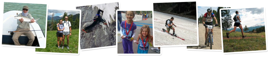
Running – Like many things in my life, it’s a topic that I’m obsessed with at times. It’s also something that I never get tired of talking about. So, be prepared.
Fly Fishing – Ever since my grandfather put a fishing rod in my hand, I’ve been smitten by fishing. Some twenty years ago I was introduced to fly fishing, and I’ve never turned back. I pursue all types of fish from saltwater to backwater, and I have a particular fondness for carp on the fly.
Climbing – I don’t do much of it now, but I still love to tie into the sharp end of a rope from time to time. I’ve had the opportunity to climb in many parts of the world, and I’ve made a lot of great friends along the way. I’m sure I’ll dig up a few stories from the “good old days.”
Skiing – From 70+ ski days when Anne and I used to live in the Vail Valley to the magic carpet with my three-year old, I loves the snow.
Hunting – I’ve never embraced the idea of trophy hunting, but I’ve grown up hunting all my life mainly for food. I’ve recently discovered pheasant and elk hunting. I’ll probably wax on about cool crisp mornings in the field and the love of a good bird dog.
Bucket List – Everyone has one or, at least, they should. I’ve always had a “bucket list” of things that I wanted to do before I die. As a have the opportunity to complete an item on the list, I usually add two more. Luckily, Anne has been the perfect companion through many of those adventures. I plan to dig up the original list (and subsequent revisions) and chronicle my adventures past. I better do it now before I forget the details in my old age. Hopefully, it will inspire others to get out and live life to the fullest.
Western Contemporary and Sporting Art – I’ve recently found that I love to paint and draw. Who knew that it was hiding deep down all these years. I’m not really that good (yet), and I’ve never had any formal training. So, we’ll see where this takes me over the next few years.
Adventures with Kids – For as long as I can remember, I’ve always wanted to be a dad – yeah, it was on my “bucket list.” Now, I have two beautiful daughters, and I want to teach them everything I can and watch them grew to be strong, independent women. I’ll probably post quite often on our family adventures.
…and a few other topics that I can’t pigeonhole into a nice category.
I hope you’ll join me.


